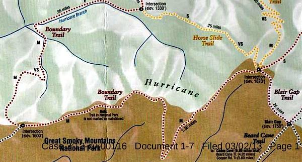
This map, said to have come from Blackberry Farm Resort, shows two trails -- the Boundary Trail and the Blair Gap Trail -- that are not listed on Great Smoky Mountains National Park's official trail map/Southern Forest Watch
Sometime in recent years two trails running more than a mile-and-a-half were cut into the backcountry of Great Smoky Mountains National Park, allegedly for the use of a private resort that borders the park, according to court documents.
When contacted by the Traveler, park officials declined to discuss the trails, or even acknowledge their existence, as their presence has been raised in litigation. However, the "Boundary Trail" and "Blair Gap Trail" depicted on a trail map purportedly handed out by the Blackberry Farm Resort do not match any trails on the park's official trail map. Together they run along the park's western boundary roughly from the Beard Cane Trail to the Cane Creek Trail. Officials at the resort, where rooms start at $745 a night, had no immediate comment when asked about the trails this week.
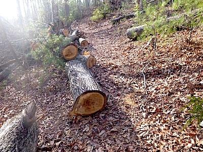
A trail of downed trees allegedly marked an illegal trail cut in Great Smoky Mountains National Park/Southern Forest Watch
The existence of the trails surfaced in connection with a lawsuit brought against the Park Service by Southern Forest Watch, a nonprofit group organized to overturn the park's $4 per night fee charged on backcountry travelers. Though not central to the fight over the backcountry reservation system, the group pointed to the "illegal trail system" as part of a pattern of "political patronage" that former park Superintendent Dale Ditmanson oversaw. Mr. Ditmanson, who instituted the backcountry fee system in 2013, retired from the Park Service earlier this year.
By allowing the Blackberry Farm Resort to maintain these trails for the use of their customers and residents, Great Smoky Mountains officials were limiting the general public's access to the park's backcountry and allowing it to be impaired, charges Southern Forest Watch's lawsuit.
The Park Service, in court documents responding to Southern Forest Watch's complaint, denied allowing a "private resort to maintain and utilize their own separate, exclusive network of trails into, on and within the boundaries" of the park. However the agency did admit that there was a signpost with a map box located outside the park boundary and that "any signs that were erected within Park boundaries by Blackberry Farm Resort were erected without permission from NPS and have since been removed."
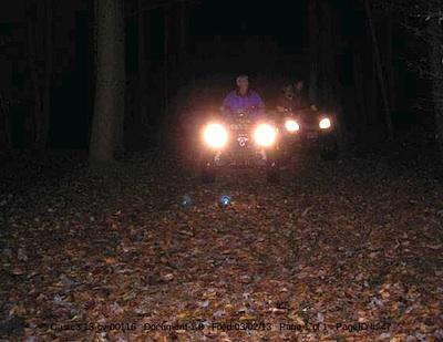
These ATVers allegedly were entering Great Smoky Mountains National Park from the Cane Creek Trailhead/Southern Forest Watch
The trail map showing the Boundary and Blair Gap trails came from the map box on the signpost, according to Southern Forest Watch's lawyer.
The trail signs and maps were found by John Quillen, a member of Southern Forest Watch. A park volunteer who regularly hikes the Cane Creek Trail to help maintain it, Mr. Quillen discovered the Boundary Trail in 2009 when he came upon a trail of trees that had been chainsawed down. He and some friends also heard a chainsaw at work, and encountered riders on two all-terrain vehicles who allegedly claimed they had come from Blackberry Farm. Photos of a trail sign, the ATV, and downed trees are part of Southern Forest Watch's court filing.
No court date for the matter has been set.


Comments
Acquired from whom? Not the NPS. The NPS never owned the tract, how could they give it away?
The lawsuit doesn't represent facts or evidence. Merely accusations.
EC.
It started out as an accusation. You are correct; however, the NPS actually admits they did it.
"...67. Defendants deny Paragraph 67, except to only admit that tract 1.13 was acquired by former Tennessee governor, Don Sundquist, sometime before 2004 and that the Ace Gap Trail was legally relocated off this privately owned tract of land...."
The NPS admits to moving a trail that had existed on his land for almost a century to "off his land."
When the King has control of something for almost a century (actually 1 year), the King owns it. Period. The question then becomes how much the King has to pay for it, unless the time lapses to sue the King....which it did here.
They gave the property back to him.
Fortunately, we don't live in a kingdom and don't have a King. We do have adverse prescriptive easment laws but there is no evidence presented here that the use was adverse, notorious and continuous, all requirements for prescriptive easement. Further the NPS would have had to excercise their right of prescriptive easement and have it judicated in court. They didn't do that. Is not stealing the land in the first place "giving it away"?
It makes far more sense to me that the NPS moved the trail not to "give back land" but to move it away from a home that had been built on rightfully owned property.
The fact the lawsuit claim "eminent domain" demonstrates how ill informed the complaintants (and their attorneys) are.
Anybody have a link to a copy of Exhibit F? I would like to see the orginal Ace Gap trail in relation to Mineral Springs Road.
Looks to me like the trail may have been moved for the convenience of the NPS -i.e. get it (the trail) away from increasing development on privately owned property north of the park.
Submitted by ecbuck on May 27, 2014 - 7:33pm.
Agreed rmackie. Its not up to "others" to decide they want a trail reopened and it certainly isn't appropriate for the NPS to pretend it isn't happening.
EC.
No King around these parts huh? Not studied up on Common Law recently? or inverse condemnation?
You are correct that complainants and especially their attorneys are ignert. King George, sort of like you, would have called us rabble.
Yep Smokies - and I stand by that statement. Other than the ranger that I have chastized previosly, I don't see any evidence that the NPS (management) pretended it didn't happen.
Yeah EC, and you probably didn't believe that the NPS would fire someone for blowing the whistle when trees were cut to accomodate a famous person either, huh Danno?