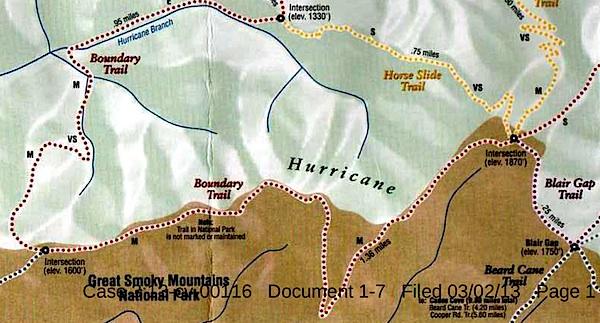
This map, said to have come from Blackberry Farm Resort, shows two trails -- the Boundary Trail and the Blair Gap Trail -- that are not listed on Great Smoky Mountains National Park's official trail map/Southern Forest Watch
Sometime in recent years two trails running more than a mile-and-a-half were cut into the backcountry of Great Smoky Mountains National Park, allegedly for the use of a private resort that borders the park, according to court documents.
When contacted by the Traveler, park officials declined to discuss the trails, or even acknowledge their existence, as their presence has been raised in litigation. However, the "Boundary Trail" and "Blair Gap Trail" depicted on a trail map purportedly handed out by the Blackberry Farm Resort do not match any trails on the park's official trail map. Together they run along the park's western boundary roughly from the Beard Cane Trail to the Cane Creek Trail. Officials at the resort, where rooms start at $745 a night, had no immediate comment when asked about the trails this week.
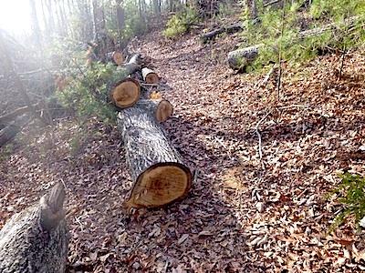
A trail of downed trees allegedly marked an illegal trail cut in Great Smoky Mountains National Park/Southern Forest Watch
The existence of the trails surfaced in connection with a lawsuit brought against the Park Service by Southern Forest Watch, a nonprofit group organized to overturn the park's $4 per night fee charged on backcountry travelers. Though not central to the fight over the backcountry reservation system, the group pointed to the "illegal trail system" as part of a pattern of "political patronage" that former park Superintendent Dale Ditmanson oversaw. Mr. Ditmanson, who instituted the backcountry fee system in 2013, retired from the Park Service earlier this year.
By allowing the Blackberry Farm Resort to maintain these trails for the use of their customers and residents, Great Smoky Mountains officials were limiting the general public's access to the park's backcountry and allowing it to be impaired, charges Southern Forest Watch's lawsuit.
The Park Service, in court documents responding to Southern Forest Watch's complaint, denied allowing a "private resort to maintain and utilize their own separate, exclusive network of trails into, on and within the boundaries" of the park. However the agency did admit that there was a signpost with a map box located outside the park boundary and that "any signs that were erected within Park boundaries by Blackberry Farm Resort were erected without permission from NPS and have since been removed."
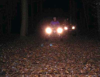
These ATVers allegedly were entering Great Smoky Mountains National Park from the Cane Creek Trailhead/Southern Forest Watch
The trail map showing the Boundary and Blair Gap trails came from the map box on the signpost, according to Southern Forest Watch's lawyer.
The trail signs and maps were found by John Quillen, a member of Southern Forest Watch. A park volunteer who regularly hikes the Cane Creek Trail to help maintain it, Mr. Quillen discovered the Boundary Trail in 2009 when he came upon a trail of trees that had been chainsawed down. He and some friends also heard a chainsaw at work, and encountered riders on two all-terrain vehicles who allegedly claimed they had come from Blackberry Farm. Photos of a trail sign, the ATV, and downed trees are part of Southern Forest Watch's court filing.
No court date for the matter has been set.


Comments
Or, what we here in the Smokies call, "another Ditmanson deal with the aristocracy."
Thanks for the article, Kurt. I enjoy much on this site, and even when I don't enjoy a piece such as this one, I appreciate the info and the resolve to publish it.
A formula for corruption: unaccountable bureaucrats, wealth, high political connections.
I agree, Kurt, thank you for having the resolve to publish this. As a historian who has studied the parks' relationships with surrounding businesses, landowners, etc., and who has looked, in particular, at the class politics of the parks in the southern Appalachians, I cannot say I am surprised by this--though I know no more than I have read here about the specifics of this case. Anyway, thanks for an interesting piece on an issue I will continue to follow.
I would like to point out some errors found in this article.
The boundary trail and blair gap trail is from the CCC days where they attempted to make an entire trail around the park boundary. It was more than likely routed from an old cherokee route. There are many trails in the park that are from ancient cherokee routes. They usually followed drainage's or mountain ridges, that were used for hunting and gathering. Portions of the AT is an example of a reclaimed cherokee trail.
This extensive boundary trail is part of a series of trails (cove mountain, little greenbrier, roundtop, chestnut top, scott mountain, rich mountain and ace gap) and these trails are maintained by the park and are inside the park boundary. I have walked a majority of these trails many times, and many of these trails are within a few hundred feet of private land. In quite a few areas you can come across homes, and roads that are adjacent to the park boundary by a mere 100 feet or so. The park boundary is marked in many cases with metal tags that are placed on trees along the border. Almost all of these trails, and especially the trails of cove mountain, scott mountain, and roundtop have manways that connect to them from these private lands. Many of these unmarked manways have existed for a long time, in many cases before the park existed. A manway, that is known by locals can be used to get into a place that is not marked officially on park maps, but is very well known - the White Oak Sinks. That starts around a property near the Scott Mountain trail, but it existed before the area became a park and connected with the schoolhouse gap trail (which locals used to get back and forth into tuckaleechee valley). There are also manways on Roundtop, and quite a few on Cove Mountain that access these main trail areas. Only locals seem to know about these footpaths, but they exist and people still use them, and they have been used for decades longer than the accusations in this article.
Hurricane ridge is an old manway trail that was abandoned, and was part of this big boundary trial. The accusations that blackberry farms made this trail is unfounded and not true. This trail existed long before the resort, and some hikers still use that old manway, and it butts up to private land. Beard Cane Trail has a manway that can be found going up that drainage into private property for close to a mile. Most of that trail is in the park, but the true trailhead starts on private land. That's also listed on this map above. Some other trails in this area like the Goldmine also start on private land, but enter the park.
Just because it's not officially listed on a park map doesn't mean it doesn't exist. There are many such manways like that. I pointed out the White Oak Sinks as a case in point. White Oak Sinks is very well known locally and recieves many park visitors, especially during the wildflower bloom. It has at least 4 unmarked trails leading into it (maybe more, but I haven't discovered all of them yet). There are hundreds of manway trails that exist in the park, and were either abandoned or no longer maintained. These are usually decade (to century) old footpaths with lots of debris to jump over, but the trails are usually defined, although nature does work hard to reclaim them.
Hurricane Ridge is also the brunt of an area that receives extreme mountain wave wind activity. It's aptly named, and almost every decade giant wind gusts take out large sections of the forests. I'm sure this is probably part of the reason the trail was abandoned was during one of these blow down events in previous decades made it very hard to consistently maintain. Just recently a tornado went through this area in 2011 and the tree blow downs was extensive. Damage can still be found within abrams creek, and over to beard cane. We have a video on this subject that was done after this area was hit. I have floated this area, and the damage is extensive and looks like something out of a disaster movie. A derecho also went through this same area in 2012, and more trees were blown down. I don't know if this is part of the reason hurricane ridge was abandoned, but my guess is that's probably the case is that it constantly requires large scale maintenance from these blow down events. It's not uncommon to see some old manways be cleared of blow down or fallen tree debris by locals. Although the park does not maintain these old manways, and just maintains the official park trails.
I'm not sure if that is the case here, but the accusations that blackberry farms and an "aristocracy of locals" cut a trail through the park is unfounded.
https://www.youtube.com/watch?v=PlnGMxBGk6I
And here is an article on the torando damage:
http://research.franklin.uga.edu/cjpeterson/research/lanscape_patterns
Gary Wilson,
You are DEAD WRONG! As someone who has seen the hundreds of cut trees along the boundary trail and personally witnessed the ATV incident you are sidestepping the main issue. The trees were cut before the hurricane damage and there are hundereds of them. The real question is did the NPS cut the trees for the private resort or did the private resort cut them while the NPS looked the other way. Under Ditmanson there were a lot of things that got swept under moss here. But there is irrefutable proof and multiple witnesses to both affairs. Every trail in the Smokies was born of something else be it a game trail or Cherokee pathway or Confederate salt peter run, matters not. That boundary trail is now claimed on the map posted in this article as part of a private trail exclusive to that resort. That is the only real issue here. How can a private resort do such a thing? With the complicity of the NPS. There is no way they "didn't know" about this. Why do you think the NPS and the private resort have "no comment"? Because they are flat busted. And folks are outraged, as they should be. The NPS doesn't belong to a 700 dollar per night resort, it belongs to the people who forfeited that land and their heirs and the US taxpayers. Not a private resort that specializes in flying Sheiks in from Saudi Arabia where they can pretend not to follow their religious beliefs for extravagant weekends of debauchery.
Just because an old manway route, that anyone can locate on a historical map if they did some research, appears on someones "recreation map" does not by any means make it a "private trail" exclusive to the farm. Anyone can hike these two manway trails, if they want.
Your accusations are just that - accusations. And i'm not sidestepping anything.
If ATV's are using these trails within the park, especially a trail like beard cane then this would be something that would be brought to light on our facebook pages or online. We are very tied in with the park, it's many tourists, and many of it's hikers and adventurists. Everytime a yellow lady slipper is poached, or a cabin is marked, we are instantly made aware of it thanks to our facebook activity.
I personally, don't care what goes on at Blackberry Farms, it's not my concern. It's their private resort, and they can house who they want. I have no ties to that resort.
I do care about what happens in the Smokies boundary though, and have a stake to see it remains protected. With that said, this can easily be fact checked with a simple camera, a gps, and a pair of boots. And I plan on doing just that.
"I personally don't care what Blackberry does?" If they cut hundreds of trees in the Smokies you had better care. That is what friends groups and GSMA are supposed to care about. Too bad you guys are more concerned about courting donors and throwing shindigs at private resorts to be bothered with a few hundred trees cut and ATV's running pall mall in the Smokies.
For the rest of us non landed aristocracy, we actually give a crap. Let me know how your little investigation goes. Sounds like it would do you some good to get out on the trail. I can show you where they have probably removed their trail sign within the park. And ignore the stumps along the way. It was probably just a result of clear cut hurricane damage LOL.
Gary, we're on the same page then.